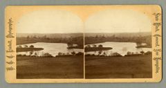
Island and pond
- Collection
- Shakers- General collection
- Alternative Title
- Island and pond, Canterbury, New Hampshire
- Item Media Type
- CreativeWorkSeries
- Contributor Name
- Kimball, W. G. C., 1843-1916
- Publisher Name
- Kimball, W. G. C., 1843-1916
- Date
- 1750 to 1900s
- Language
- English
- Extent
- 2 images
- Place of Publication
- Concord (N.H.)
- Note
Description: View across a field to a pond with an island. Seen amidst the trees, across the pond, on the right is a building. Based on the maps of Canterbury in David Starbuck's Canterbury Shaker Village: Archeology and Landscape, pages 96 and 97, the view is of Turning Mill Pond. The island is designated as "Boys' Island." The turning mill is located opposite the island.
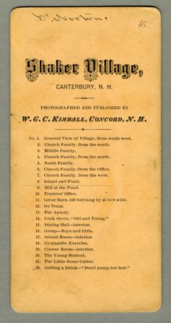
Inscriptions: Dr. Norton
Provenance: Stiles Collection
Donor: Stiles, Lauren; Stiles, Julie
- Subject Name
- Shakers
- Subject Geographic
- Canterbury (N.H.)
- Merrimack County (N.H.)
- New Hampshire
- Shelf Location
- Original digital object name: yhm-spe-sha-ste-cnh-016
- Hamilton College Library, Communal Societies, Shakers, Stereoviews, cnh-016
- Restrictions on Access
- There is no restriction on access to this material.
Kimball, W. G. C. .
(1750-1999).
Island and pond.
Digital Collections, Hamilton College Library.
https://litsdigital.hamilton.edu/do/c02367b7-84f7-4a4b-8b57-1ee7ffa5cf55
APA
Kimball, W. G. C. .
(1750-1999).
Island and pond.
Digital Collections, Hamilton College Library.
https://litsdigital.hamilton.edu/do/c02367b7-84f7-4a4b-8b57-1ee7ffa5cf55
Kimball, W. G. C..
1750-1999.
“Island and pond”.
Last modified March 17, 2023.
Digital Collections, Hamilton College Library.
https://litsdigital.hamilton.edu/do/c02367b7-84f7-4a4b-8b57-1ee7ffa5cf55
Chicago
Kimball, W. G. C..
1750-1999.
“Island and pond”.
Last modified March 17, 2023.
Digital Collections, Hamilton College Library.
https://litsdigital.hamilton.edu/do/c02367b7-84f7-4a4b-8b57-1ee7ffa5cf55