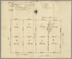
The whole amount of land in the annexed plan from actual survey is 1300 16/100 acres by Alfred Wolcott, Surveyor. Copy made Apl 18th, 1818
- Collection
- Edward Robinson
- Item Media Type
- Manuscript
- Contributor Name
- Robinson, Edward, 1794-1863
- Robinson, William, 1754-1825
- Wolcott, Alfred, active 1818
- Tuttle, Linius
- Upson, Saul
- Skinner, Abraham (of Twinsburg, Ohio)
- Allen, Lewis (of Twinsburg)
- Date
- September 29th, 1817 to April 18th, 1818
- Language
- English
- Extent
- 2 images
- Abstract
- Q 1818, April 18 Ohio land documents: On 29 Sept. 1817, Alfred Wolcott, surveyor, drew up a map of 8 parcels of land totaling 1300 acres. A copy of this map was made 18 April 1818 for William Robinson of Southington Ct. who had purchased lots 1, 2, 7, 8, totaling 636.43 acres, at $5. per lot from Linius Tuttle. This transaction was completed April 17, 1818. These four lots bordered the land of Upson, Allen, Skinner, and Tuttle. The exact location (i.e. town) of the land is not mentioned here but is cited in subsequent correspondence.
- Note
Twinsburg, Ohio: deeds, documents, and letters (1818–1830s) pertaining to the 636 acres originally owned by William Robinson, father of E. R.
- Subject Geographic
- Twinsburg (Ohio)
- Southington (Conn.)
- Shelf Location
- Original digital object name: yhm-spe-rob-q01a
- Hamilton College Special Collections, Robinson Collection, q01a
- Restrictions on Access
- There are no restrictions on access to this resource.
Robinson, E. , Robinson, W. , Wolcott, A. , Tuttle, L. , Upson, S. , Skinner, A. T.
& Allen, L. T. .
(1817-1818).
The whole amount of land in the annexed plan from actual survey is 1300 16/100 acres by Alfred Wolcott, Surveyor. Copy made Apl 18th, 1818.
Digital Collections, Hamilton College Library.
https://litsdigital.hamilton.edu/do/4a03d116-ee77-450d-9021-f236e9f6b7c9
APA
Robinson, E. , Robinson, W. , Wolcott, A. , Tuttle, L. , Upson, S. , Skinner, A. T.
& Allen, L. T. .
(1817-1818).
The whole amount of land in the annexed plan from actual survey is 1300 16/100 acres by Alfred Wolcott, Surveyor. Copy made Apl 18th, 1818.
Digital Collections, Hamilton College Library.
https://litsdigital.hamilton.edu/do/4a03d116-ee77-450d-9021-f236e9f6b7c9
Robinson, Edward, Robinson, William, Wolcott, Alfred, Tuttle, Linius, Upson, Saul, Skinner, Abraham (of Twinsburg
and Allen, Lewis (of Twinsburg).
1817-1818.
“The whole amount of land in the annexed plan from actual survey is 1300 16/100 acres by Alfred Wolcott, Surveyor. Copy made Apl 18th, 1818”.
Last modified November 06, 2023.
Digital Collections, Hamilton College Library.
https://litsdigital.hamilton.edu/do/4a03d116-ee77-450d-9021-f236e9f6b7c9
Chicago
Robinson, Edward, Robinson, William, Wolcott, Alfred, Tuttle, Linius, Upson, Saul, Skinner, Abraham (of Twinsburg
and Allen, Lewis (of Twinsburg).
1817-1818.
“The whole amount of land in the annexed plan from actual survey is 1300 16/100 acres by Alfred Wolcott, Surveyor. Copy made Apl 18th, 1818”.
Last modified November 06, 2023.
Digital Collections, Hamilton College Library.
https://litsdigital.hamilton.edu/do/4a03d116-ee77-450d-9021-f236e9f6b7c9